A slide show explains the importance of
acquiring a True 3D field data set
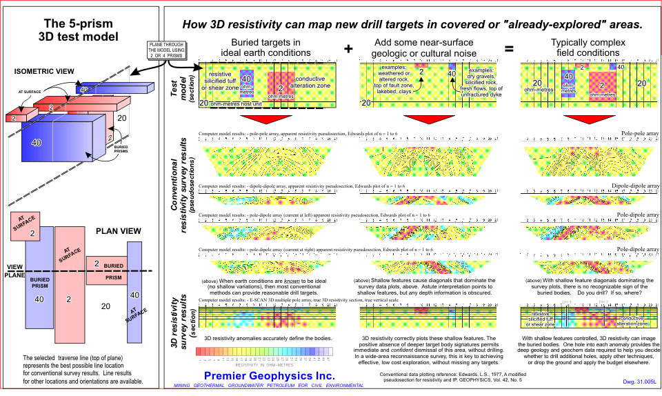
Mouse here for a one-image preview.
Crone E-SCAN® 3D RESISTIVITY MAPPING
True 3D DC resistivity earth mapping for geoscience and engineering
103-190425-01a
A
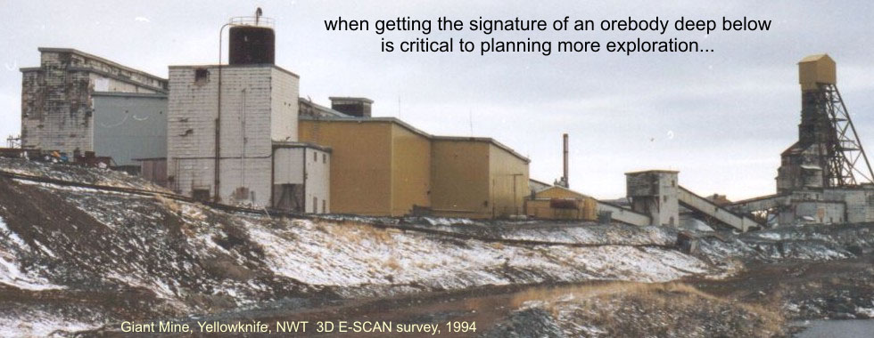
Introduction: 3 D D C R E S I S T I V I T Y M A P P I N G System scale (2-4 Km depths)

THIS IS 3D DC RESISTIVITY MAPPING...
Highly resolved True 3D imagery
at unprecedented depths.
At right, an isosurface rendering of the hands-off 3D inversion results of a dense, uniformly distributed, uniformly all-directional "True 3D" field resistivity data set brings to life the electrical signature (alteration imprint) of an upwelling hydrothermal system.
3D DC resistivity mapping objectively images the strong and the subtle variations in the steady-state (DC) electrical resistivity conditions throughout a selected volume of the earth.
The explorationist or engineer is provided with a detailed overview of geo-electric patterns and zoning that will be interpreted variously as host rock formations, variable alteration effects, structures, potentially mineralized zones, and a number of indirect pattern indicators that can point the way to hidden resource targets which may not show up electrically at all.
Verifiably hard-data-constrained and objective "True 3D" imagery has important applications in resource exploration, both greenfields and brownfields, in site sterilization studies, and across a wide range of mineral, groundwater, engineering and other studies.
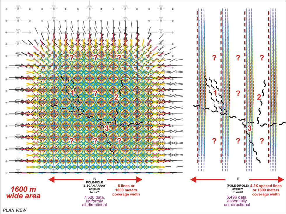
The key: a dense "True 3D" field data set.
At far right, a hidden rangefront fault has multiple cross-breaking features, any of which may represent the actual local mineralization host. While we usually guess correctly in placing the survey lines perpendicular to the expected main fault orientation, uni-directional line data such as these can neither recognize nor "data capture" these sub-parallel cross-breaking features.
The dense, all-directional "True 3D" data set at left obviously samples not just the rangefront fault, but it captures all details of every other possible orientation and shape of structure and zone. Uniformly, in every aspect... This is the key to ensuring an objective True 3D inversion model, including the more subtle features that may represent ore signatures.
Data sets such as at right (parallel uni-directional lines of data) are often inversion-processed as "3D", and indeed, the resulting "3D" earth model will actually look like reasonable geology, - apparently ready to drill. But when you examine the field data used for the inversion, there is clearly a lot of interpolation and guesswork being applied by the inversion in the absence of sufficiently dense sampling "between the lines".
CAVEAT EMPTOR: to save $35K on a "less-than True 3D" field survey, the explorationist risks spending multiples of that on drilling misses, perhaps failing to even see that the real resource anomaly exists only in cross-breaking zones, and walking away empty.
Applications in exploration for geothermal energy, lithium brine, deep magmatic nickel, IOCG, deep sedex sulphides, - and what else?
B
Introduction: 3 D D C R E S I S T I V I T Y M A P P I N G Very deep (800m - 1,500m)
THIS IS 3D DC RESISTIVITY MAPPING...
Illuminating unseen deeper connections
and 3D resource model imagery.
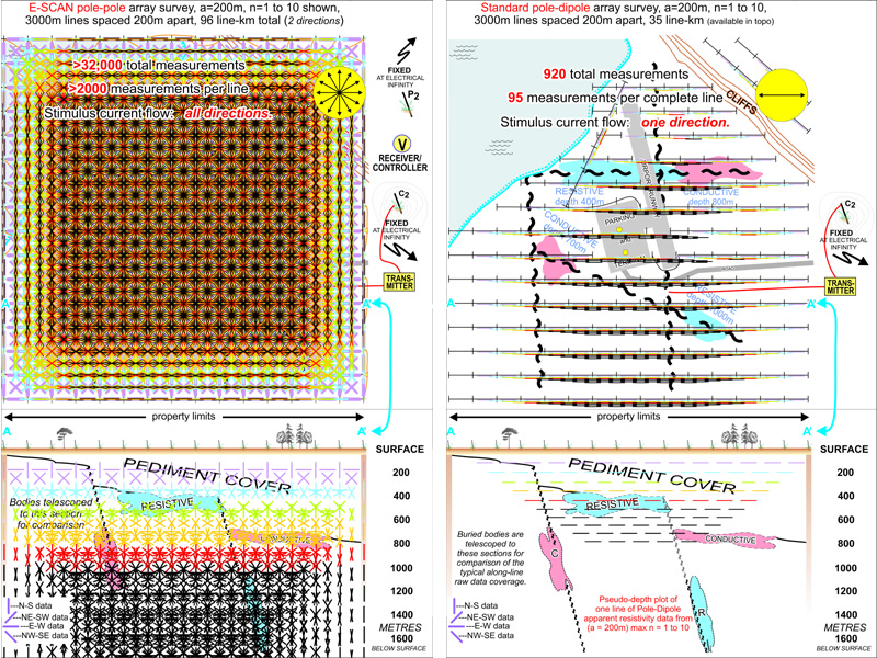
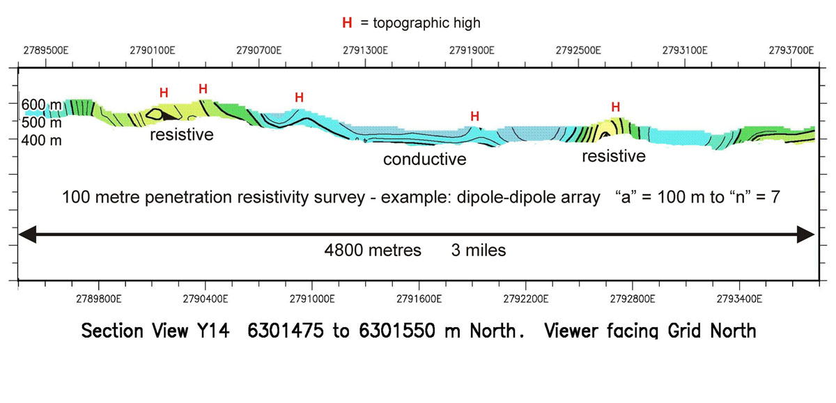
Before True 3D resistivity broke the cost barrier (Crone 3D E-SCAN), a tremendous amount of exploration for minerals and geothermal energy was conducted by line surveys using dipole-dipole and pole-dipole array configurations. While claims of much greater depth penetration are frequent in reports, there are many papers and even a lookup table that can tell you exactly what your best-conditions effective depth of investigation is, for any given array, dipole length and pole or dipole separation. Consider this three mile long resistivity traverse line (effective depth ~ 100m) that crosses a series of prospective erosional remnants with obvious silica and maybe some sniffs of gold.
The inverted results tell you approximately what you thought you wanted to know... the outcrops are resistive, as expected, and they extend from "here" to "there" in each case, identifying the approximate width beneath which you will drill to intersect their respective feeder structures (for potential bonanza gold mineralization). There have been hundreds (if not thousands) of such geophysics+drilling plays across Nevada and indeed across the world. The vast majority of these programs have come up empty, and been dropped, often due to a lack of whole-system imaging.
The "Big Picture" 3D overview
defines your exploration model,
and guides fewer drill holes to better targets.
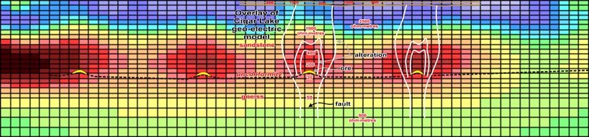
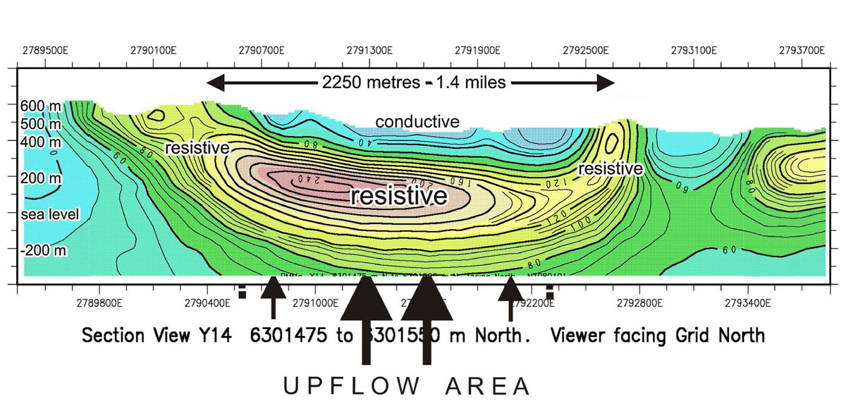
Now consider the same area being surveyed by a large scale "True" 3D resistivity survey. A true vertical section through the 3D earth model is shown. (You can see where the 100 m traverse results came from... a legitimate borrow for our purposes.) Suddenly, the widely separated individual prospects are seen to be not so individual. They are parts of the same deep hydrothermal system. The strategy to drill vertically below the individual silica hot spring vents is now seen to be useless,- not the target setting that was expected.
Instead, we have a plethora of target areas, all defined in True 3D through a thousand meters of vertical extent. The central pink resistive boiling zone is prospective, as are its upper and lower edges. The upward leakage pathways that escape from under the boiling zone "cap" are prospective conduits. Even the conductive alteration directly above the boiling zone (vertically escaping gases) represents a potential zone of disseminated sulphide-gold mineralization. Last, but not least, a deep-pockets explorer may want to angle-drill directly below the boiling zone to test the vertical conduit structures that delivered the copious hydrothermal fluids that were responsible for this large scale alteration/mineralization pattern. (In Nevada, at the Hollister deposit, a smaller version of this pattern is underlain by 1.5 million ounces of gold in feeder faults in the crystalline basement, discovered by angle drilling in the manner suggested for this deeper pattern.)
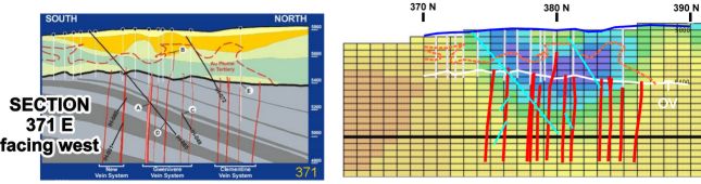
The Hollister Model Recognize the resistive (blue) boiling "cap"? What about the "bull horns" pattern of hydrothermal fluid flow escaping from the edges of a cap, and rising toward surface?
Mineralized hydrothermal fluids rising in basement faults have depressurized upon entering the overlying volcanics, boiled, and established an impermeable cap. Fluids escaping past the cap's edges reached the surface and vented as hot springs, looking from the surface like two separate systems, each marked by sinters. These were vertically drilled (white traces) with no luck. Decades later, one smart angle hole (black at left, blue at right) intersected the two meter wide, geophysically-undetectable quartz veins in the basement, leading to a 1.5 million ounce gold discovery. The highgrade basement veins remain undetectable by any remote sensing to this day, but the "bull-horns" signature of the overlying hydrothermal flow system imprint tells you immediately where you should drill to find the inferred feeders (and the gold).
Applications in exploration for binary geothermal, lithium brine, IOCG, sedex sulphides, gold, base metals, water resources - and what else?
C
Introduction: 3 D D C R E S I S T I V I T Y M A P P I N G Moderate depths (200 - 300 m)
THIS IS 3D DC RESISTIVITY MAPPING...
Resolving difficult targets in complex settings.
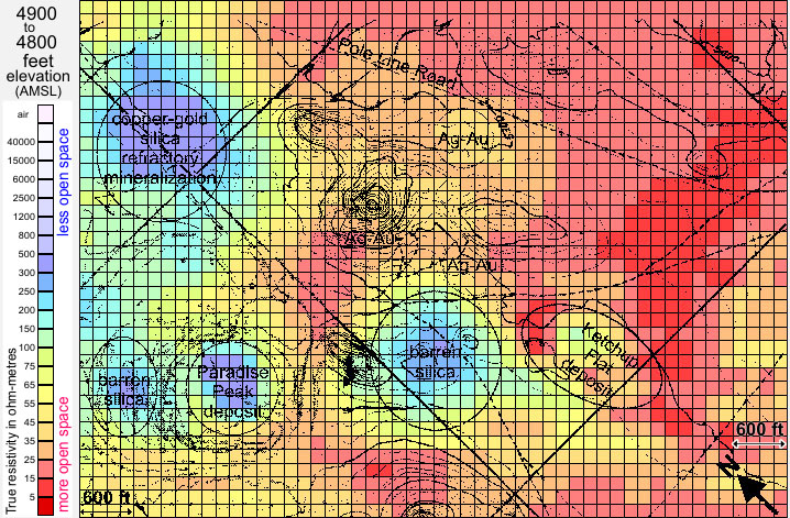
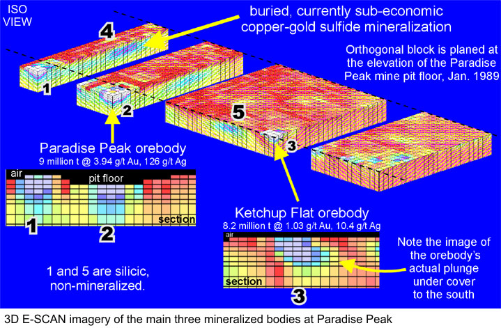
At right, three siliceous silver-gold orebodies are obvious in this cutaway of the 3D inversion mesh, the result of processing a 3D E-SCAN "True 3D" field data set obtained in 1989.
The cutaway mesh display is 600 feet (183m) tall, each mesh element being 75 feet (23m) square. Blue-white is over 1,000 ohm-meters, quite resistive. The dark red is less than 10 ohm-metres, representing a very conductive desert cover. Bold anomalies such as these are readily visible in this plot format in which the computer generated mesh element values are displayed without any filtering or subjective treatment such as contouring. (This historic 3D inversion is scheduled for replacement with a higher resolution mesh during 2019, using current state-of-art algorithms.)
Since participating in the pioneering 3D inversion algorithm research at the University of British Columbia (supply of E-SCAN True 3D field data sets dating from 1984 onward), 3D E-SCAN has gone on to accumulate decades of multi-commodity case experience and discoveries, an invaluable real-world resource on which to base our planning and execution of the best possible 3D field data acquisition program for just about any property or commodity target.
Perfect example of a "Brownfields" application?
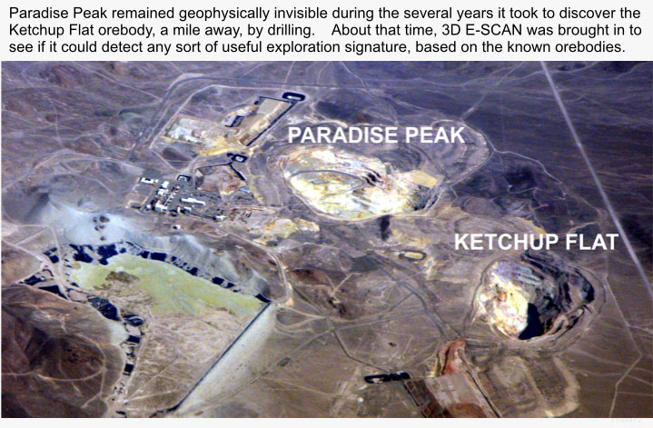
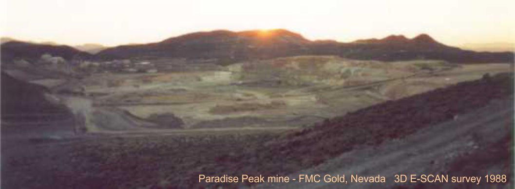
Upon discovery of the outcropping Paradise Peak orebody in the early 1980's, FMC Gold tested every available ground and airborne system that mnight have a chance of "seeing" their orebody, - intending of course to use that signature to search the surrounding covered area for additional orebodies. Nothing worked. (We know why, now...)
Resorting to step-out pattern drilling, FMC invested in five continuous years of drilling before identifying the Ketchup Flat orebody, just a mile away from the initial discovery. About the same time, a skeptical FMC was convinced to try one more technology that was already having success with resistive targets in conductive host settings... 3D E-SCAN. Even the unprocessed apparent resistivity data immediately showed the presence of the Paradise Peak and the new Ketchup Flat orebodies, and hinted at the deeply buried mineralization out toward Pole Line Road. Later inversion of this 3-week field data set brought True 3D clarity to the geometry of the three mineralized zones, and two barren silica zones, - above right.
Had 3D E-SCAN been applied immediately after the Paradise Peak discovery, the mine plan would have been quite different. A larger tailings dam would have been designed up front. Initial mill design might have included a roaster circuit to access the refractory Pole Line ore,- silica encapsulated copper-gold. And by swinging the survey coverage around to the north, there is no doubt that the County Line deposit would have been included in the mine planning.
3D mapping at Paradise Peak was done without interruption to mining operations, an example of ultimate brownfields efficiency.
A similar case: At right, resistive ore remaining in the pit floor of the Freedom Flats deposit (Borealis Trend, NV) is seen extending west into the pit wall, while waste dumps innocently placed above make any pit wall advances in that direction extra expensive.
Had 3D E-SCAN imagery been obtained shortly after the initial discovery, the mining plan for this deposit would have at least relocated these dumps, to retain the option to push back the pit wall.
It is interesting to speculate that a program of intensive, all-possibilities True 3D resistivity mapping could be effectively applied to many current producing properties, and across each of the hundreds of under-explored past-producing properties like Borealis. And on-trend cover plays in general. The odds of new discoveries would seem to be high.
Applications in exploration for binary geothermal energy, lithium brine, gold, base metals, water resources, engineering, site sterilization - and what else?
D
Introduction: 3 D D C R E S I S T I V I T Y M A P P I N G Narrow and shallow: (first 100m)
 Mouse-over the image above.
Proving up new and better approaches...
We mentioned above the benefits of imaging not just the specific "expected" target, but the general host context as an assist to understanding the exploration model and perhaps facilitating discovery of otherwise undetectable or even just unexpected (different) resource bodies.
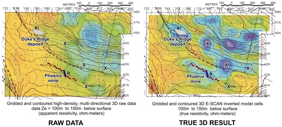
In this small-scale example, the Phoenix deposit is a single silicified vertical shear of 2 meters width, with a strike of only 60 meters. That it ran 76 ounces Au with peaks of over 300 ounces indicates why these features were sought out, regionally. Problem was, a number of majors were attempting to detect similar structures directly, by operating tiny-scale dipole resistivity traverses and EM traverses (hoping for a detectable conductive alteration envelope). Many years, very high costs, no results.
3D E-SCAN was calibrated at 100m grid spacing over the nearby flagship resource, the Lawyers Mine. Seeing a 100m radius of leakage alteration (resistive), the wide area, large-spacing survey approach was proven. Within days, the Phoenix discovery signature was mapped, about a kilometer away from the mill.
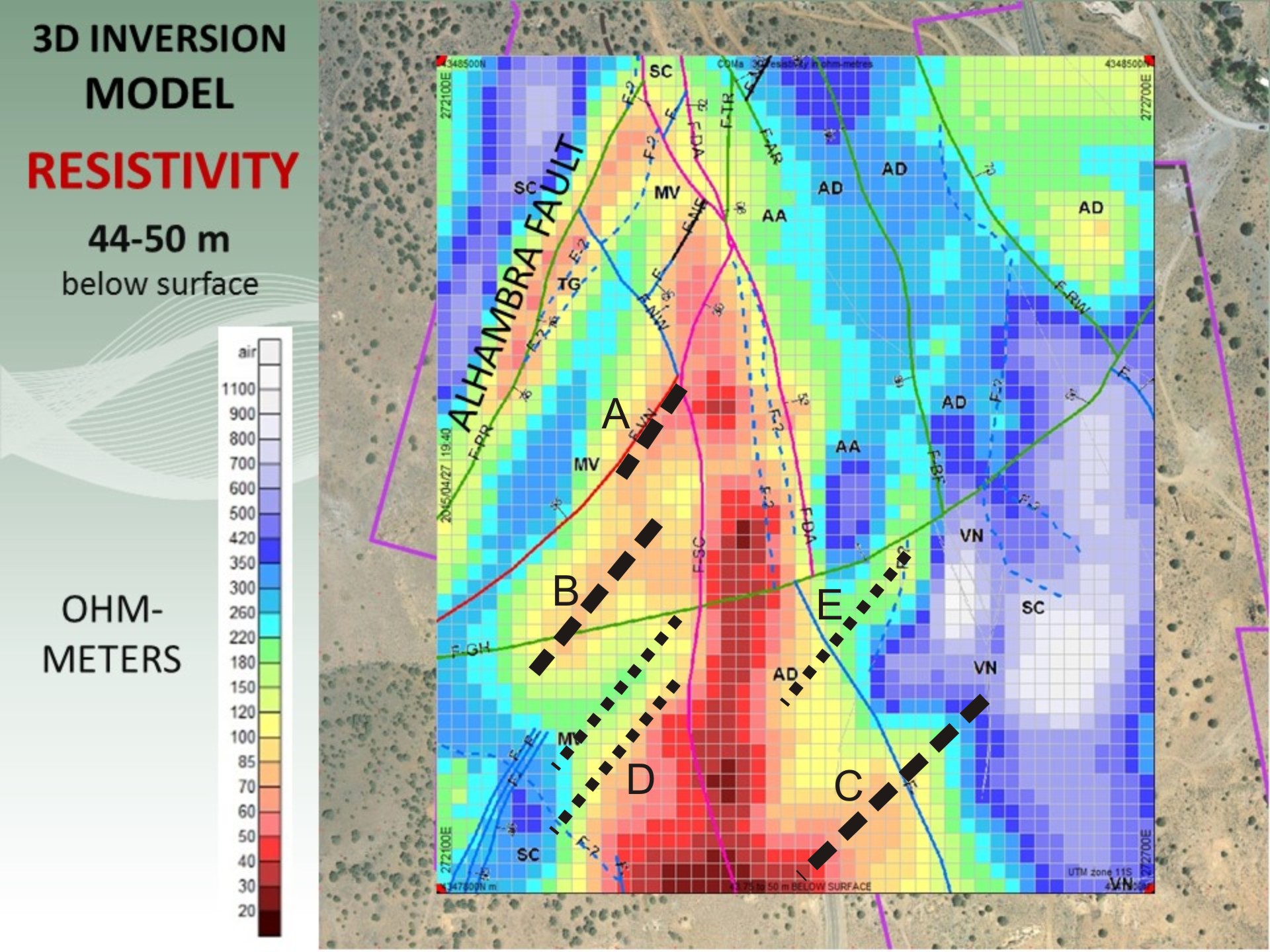
New ore signatures along the Comstock Trend.
On occasion, Induced Polarization (IP) may be indicated, though it is our experience that in a great many successful 3D resistivity programs, the added 3D IP component has not contributed to anything but higher survey costs. This program is an exception, as the objective here was to map the narrow silicic veins that host highgrade silver/gold, and also to map a newly established local association between weakly disseminated pyrite and heap leach gold values.
In the resistivity imagery, the famed Alhambra fault (silica mineralization) is seen as a conductive anomaly within the volcanic suite, proving that every site is different, and that adherence to any generic expectations for signatures is a dangerous bet.
Other unmapped structures are evident in the resistivity pattern, most adhering to the district's primary mineralization-associated azimuths. The survey was done blind, with no prior site knowledge. The IP neatly identified the known disseminated pyrite-gold zones, and established a strong (untested) IP anomaly to the south.
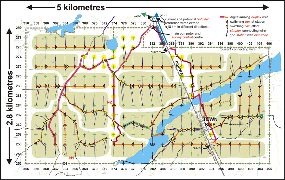
The survey area is 700 by 800 meters, and was surveyed with a 50 meter grid spacing. The displayed mesh cell dimensions are 12.5 meters square, with the shallower cells being 6.25 meters thick, increasing with depth.
Applications in exploration for gold, base metals, water resources, engineering, site sterilization - and what else?
E
Introduction:
G R E E N F I E L D S and B R O W N F I E L D S
"Today, everything is possible."
Extreme terrain, major infrastructure, deep or conductive cover, -
proven "business as usual" for 3D E-SCAN, for 37 years.
G R E E N F I E L D S
System-scale deep/wide imaging
- hydrothermal metals
- intrusive
- SEDEX
- magmatic
- IOCG
- Uranium
- Geothermal Energy
- LITHIUM Brine
- Oil and Gas
- Groundwater
 B R O W N F I E L D S
Mines and mine properties
- underground or open pit
- rough terrain / deep cover
without interference from:
- industrial installations
- grounded fences and pipes
- heavily travelled roads
- electrically powered equipment
- conductive tailings, dumps
- rubber leach pad liners
G R E E N F I E L D S
Deep or shallow open lakes
- little or no cost increase
- continuous 3D area mapping
- don't "miss" important structure
B R O W N F I E L D S
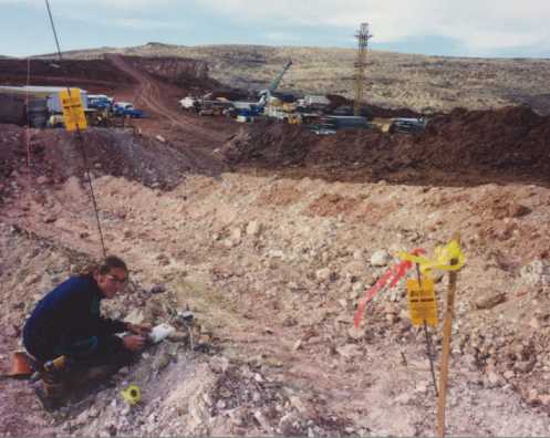
Operating open pit mine example
(included in the 3D property imagery,
with zero production interruptions)
G R E E N F I E L D S
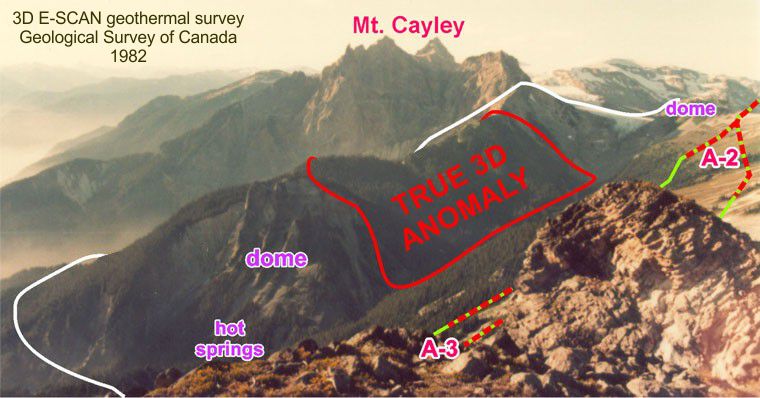
Extreme terrain example
- geothermal exploration
B R O W N F I E L D S
Trucks and people example
- 3D survey while stripping the "USX"
G R E E N F I E L D S
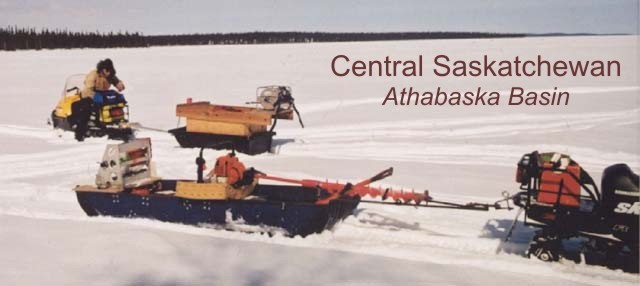
Frozen lakes
- thick ice
- minus 40 degrees C
B R O W N F I E L D S
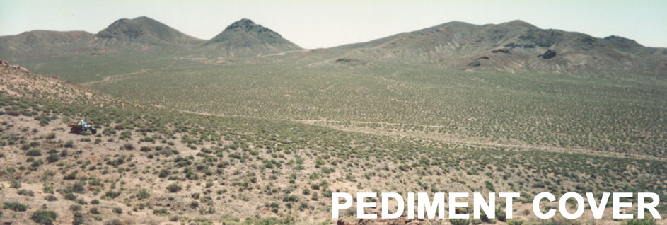
Shallow to deep (to 1000m) cover
- surrounding minesite
- surrounding geothermal power plant
G R E E N F I E L D S
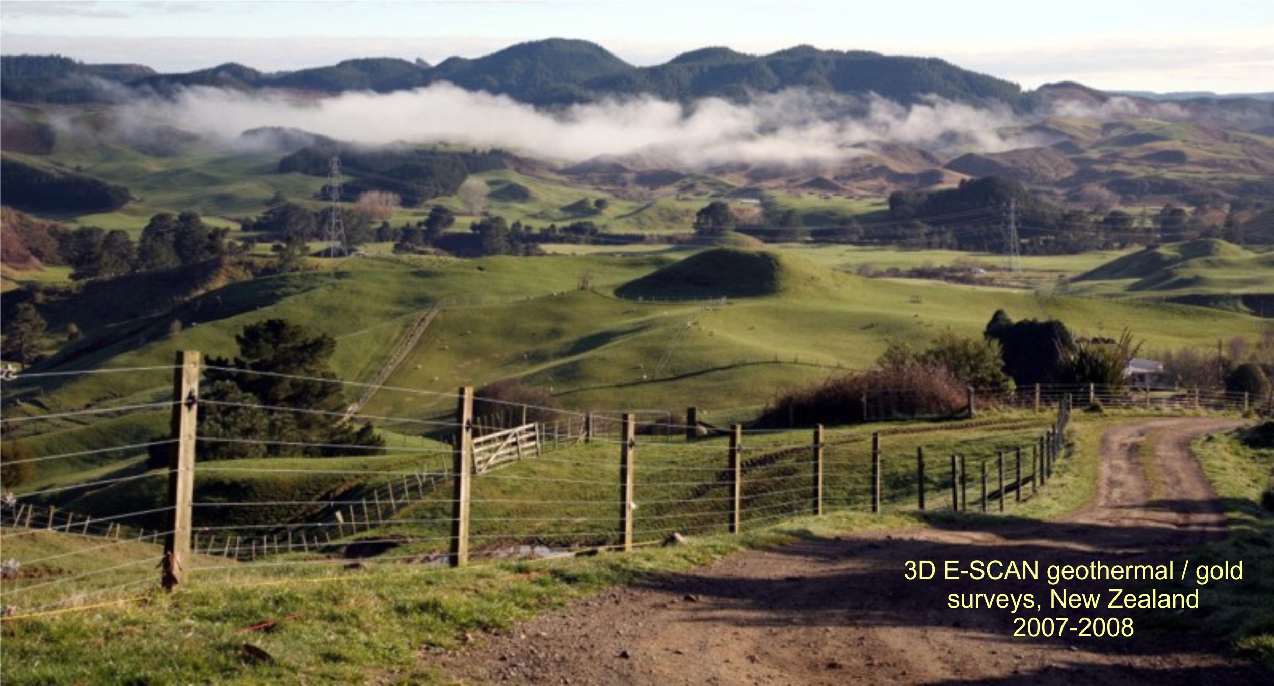
Intense agriculture and cultural presence
- electric fences
- buried pipes
- buildings, animals
- roads and people
B R O W N F I E L D S
Geophysically "undetectable" orebody
- area pattern drilling for 5 years
- a 3-week 3D E-SCAN survey test
= 3 "lookalikes", including new orebody
+ third (different) orebody also imaged
G R E E N F I E L D S
Example of a townsite
- roads and people
- power and infrastructure
- housing for nearby mine
B R O W N F I E L D S
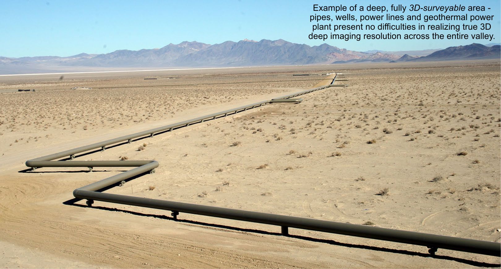
Geothermal power plant sites
- 3D resolution to 4,000 meters
- 20 to 200 km2 area mapping
without interference from:
- grounded fences and pipes
- electrically powered equipment
- transmission lines
- the power plant itself
G R E E N F I E L D S
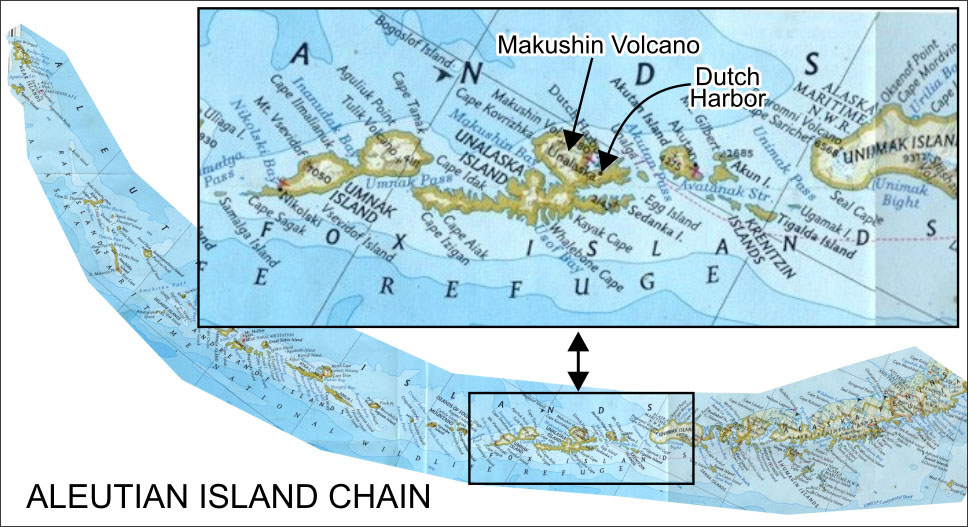
Remote access performance
- deck of freighter from Seattle
- helicopter lift to Makushin Volcano
- winds to 160 mph, dense fog
- hazardous terrain
- snow in August (summer)
- completed on time and on budget
This 1984 true 3D resistivity data set
(for Alaska Dept. of Geol. and Geophysical Surveys)
inspires UBC inversion researchers -
first true 3D algorithms evolve 1987-97.
F
SURVEY/MAP COST-EFFECTIVELY AT FULL 3D RESOLUTION ... in any terrain ...
J
SOME TIPS FOR NAVIGATING THIS WEBSITE
Some pages indicate "In Development" or "edit/incomplete". During 2019, most of this new site should be completed.
Your most reliable viewing mode right now is on a laptop, or other computer with a large screen. Adaptation to IOS deveices and smart-phone screens is taking some time.
Any questions, e-mail Greg at
e-scan@cronegeophysics.com for clarification.
Clickable
links take you to more information from which you can (usually) return.
VIEW NEW SITE PROGRESS
Move your cursor over any green text for
more details or
perspective. Find a background neutral spot to exit the blow-up.

brings related slide show.

brings related photos. Exit with browser window BACK arrow.
Click on

to load a high-resolution
Adobe PDF document to
view, print, save, send.
Time, cost, risk? buttons give you perspective.
"Good question..." -??- tries to anticipate your question and
offer a quick answer or directions to details.
A
hi-res image exceeds this site's default 1024x768 pixels. Use the browser's controls to pan across the image, and to return.
.
This image invites you to
click on image sub-areas to access more detail. Use the browser window BACK arrow to return.
Green-outlined images are active. To get away from a result, move the mouse off to any side.
After checking these tips, get started with Shore's INTRODUCTION.
© 2019 Crone Geophysics & Exploration Ltd. ver 30April2019
E-SCAN is a registered trademark of Crone Geophysics & Exploration Ltd.
available
The text may identify issues that are thought
to be important for maintaining a practical working perspective vis-a-vis the subject being discussed.
Example: Securing uninterrupted true 3D data set across the vertical cliff area in this project resulted in no additional costs to the client.
Additional time requirements: zero.
Additional risk to client: zero.
Special planning/equipment: none.
example comment: You might think that you can simply double the size of the measurement dipole
to get twice the vertical penetration (before the signal level again becomes unmanageable),- but the
lateral setup distance needed by this doubled-everywhere array may far exceed the available space.
This bigger array may encounter a steep-terrain boundary limitation, or your survey may have to go past
the legal boundary of your property, perhaps requiring you to negotiate the rights to do so.
See the main page item on Rough Terrain.
Secondary concern: a doubled dipole length also diminishes lateral resolution... Caution is required.
If you use Adobe Reader Version 9 or better (free from Adobe), you may be able to rotate some 3D PDF views, -
provided your computer's video chipset is new and powerful enough.
A low performance chipset may advance rotation in a jerky manner with lots
of wireframe artefacts between images, or it may not work at all.
Powerful 3D graphics chipsets should support smooth and seamless, albeit slow, rotation of these files.
Most PDF files you might download will not be 3D images,- just high-resolution sheets that you can review, print out, save or send.